
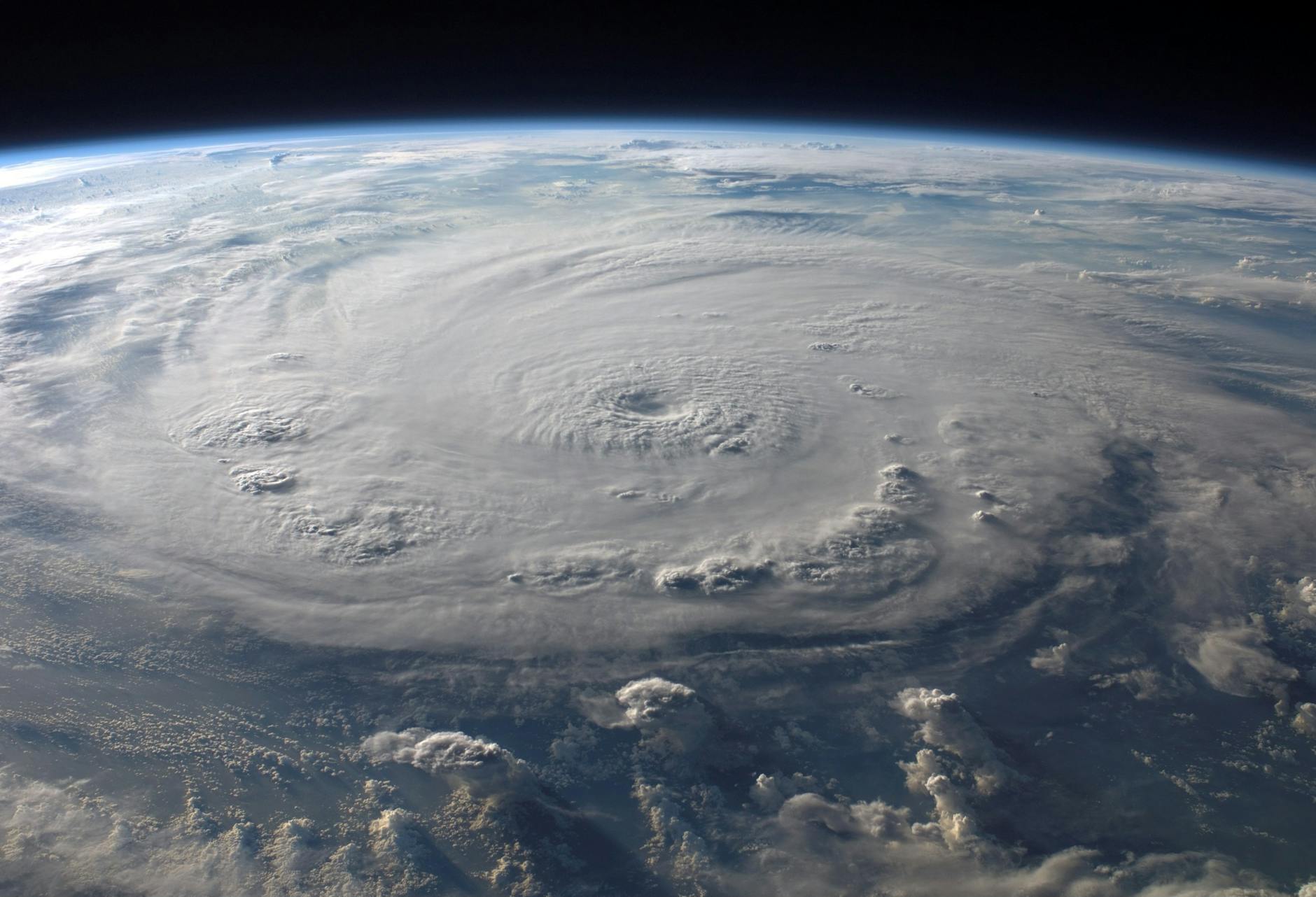
Hurricane Erin’s Fiery Ascent: A Visual Spectacle of Nature’s Power
Satellite imagery reveals the dramatic transformation of a tropical storm into a formidable Category 5 hurricane, illuminating the raw energy unleashed by a developing cyclone.
The Atlantic Ocean, a vast and often turbulent expanse, recently played host to a spectacular display of nature’s raw power. Hurricane Erin, a potent tropical cyclone, underwent a rapid and dramatic intensification, transforming from a developing storm into a formidable Category 5 hurricane. This remarkable evolution was captured in breathtaking detail by NOAA’s GOES-19 satellite, providing scientists and the public alike with an unprecedented visual chronicle of a hurricane’s ascent. The imagery not only showcases the sheer force of these meteorological phenomena but also offers a unique glimpse into the electrical activity that often accompanies their most intense phases.
The transformation of a tropical storm into a major hurricane is a complex process, influenced by a confluence of atmospheric and oceanic factors. While the destructive potential of these storms is well-documented, the visual aspects of their development, particularly the electrical displays, are often less emphasized. The GOES-19 satellite’s advanced capabilities allowed for the observation of Hurricane Erin’s burgeoning strength, revealing a mesmerizing interplay of cloud formations, wind patterns, and a surprising blaze of lightning that accompanied its climb to peak intensity.
This article delves into the fascinating journey of Hurricane Erin, exploring the meteorological conditions that facilitated its rapid strengthening, the significance of the observed lightning activity, and what these events can teach us about the dynamics of tropical cyclones. We will examine the scientific insights gleaned from satellite observations and consider the broader implications for hurricane preparedness and understanding.
Context & Background
Tropical cyclones, known by various names around the globe including hurricanes, typhoons, and cyclones, are among the most powerful and destructive weather events on Earth. They form over warm ocean waters when atmospheric conditions are favorable for the development of a rotating storm system. The primary energy source for these storms is the latent heat released when water vapor condenses into clouds and rain.
The Saffir-Simpson Hurricane Wind Scale is the standard measure used to categorize the intensity of hurricanes in the Atlantic and Northeastern Pacific basins. This scale classifies hurricanes into five categories based on their sustained wind speed. A Category 1 hurricane has sustained winds of 74-95 miles per hour (119-153 km/h), while a Category 5 hurricane represents the most extreme end of the spectrum, with sustained winds exceeding 157 miles per hour (252 km/h). The rapid intensification of a storm from a lower category to a higher one, often within a 24-hour period, is a particularly concerning phenomenon for forecasters and emergency managers, as it leaves less time for preparation and evacuation.
NOAA’s Geostationary Operational Environmental Satellite (GOES) program plays a crucial role in monitoring weather patterns across the Western Hemisphere. The GOES-19 satellite, part of this vital network, provides continuous imagery and data, enabling meteorologists to track storms in real-time and develop more accurate forecasts. Its advanced sensors can detect various atmospheric phenomena, including cloud top temperatures, water vapor content, and, importantly for this narrative, lightning activity. Understanding the distribution and intensity of lightning within a hurricane can offer clues about the storm’s structure and the vigor of its updrafts, which are critical for intensification.
Before Erin’s dramatic transformation, its development in the Atlantic followed a typical pattern for nascent tropical systems. Early-stage observations would have focused on the formation of a tropical depression, characterized by a closed circulation and thunderstorms. As environmental conditions remained favorable – such as warm sea surface temperatures, low wind shear, and sufficient atmospheric moisture – the storm began to organize and strengthen, progressing through the stages of tropical storm and then hurricane. The specific atmospheric ingredients that fueled Erin’s rapid ascent to Category 5 status are a key area of scientific interest.
The occurrence of lightning within hurricanes is a subject that has garnered increasing scientific attention. While thunderstorms are inherently electrical, the presence and prevalence of lightning in mature, intense hurricanes was historically thought to be less common than in terrestrial thunderstorms. However, advancements in satellite-based lightning detection have revealed that intense electrical activity can indeed occur within the powerful updrafts and complex microphysical processes of these massive storm systems. The lightning observed in Hurricane Erin serves as a vivid illustration of this phenomenon, highlighting the immense electrical charge separation occurring within its core.
The National Hurricane Center (NHC) is the primary authority for issuing forecasts and warnings for tropical cyclones in the Atlantic basin. Their advisories provide critical information to the public and emergency officials regarding storm track, intensity, and potential impacts. The classification of a storm like Erin into Category 5 is a serious alert, signifying a life-threatening situation.
In-Depth Analysis
The rapid intensification of Hurricane Erin from its initial stages to a Category 5 monster was a testament to a particularly conducive atmospheric and oceanic environment. While the exact trigger for such swift strengthening is often multifaceted, several key factors are typically involved. Warm sea surface temperatures (SSTs) are paramount, providing the essential fuel for a hurricane. When SSTs are at or above 26.5 degrees Celsius (80 degrees Fahrenheit), they can sustain and intensify tropical cyclones. Erin likely encountered a region of exceptionally warm ocean waters, allowing it to readily absorb heat and moisture from the sea surface.
Low vertical wind shear is another critical ingredient. Wind shear refers to the change in wind speed and direction with height in the atmosphere. High wind shear can disrupt the organized structure of a hurricane, tilting its vertical axis and hindering its intensification. Conversely, low wind shear allows the storm’s convection (upward motion of air) to remain vertically aligned, fostering a more concentrated and powerful circulation. Erin’s track likely took it through an area characterized by minimal changes in wind speed and direction with altitude.
Atmospheric moisture content also plays a significant role. A moist atmosphere reduces the likelihood of dry air entrainment, which can disrupt thunderstorms and weaken a hurricane. The presence of abundant moisture throughout the storm’s vertical column would have supported robust thunderstorm development and efficient heat release through condensation.
The electrical activity observed in Hurricane Erin, described as a “blaze of lightning,” is not merely a visual spectacle but an indicator of intense convective activity. Within the towering cumulonimbus clouds of a hurricane, vigorous updrafts transport water droplets, ice crystals, and graupel to great heights. As these particles collide and fragment, they can lead to the separation of electrical charges. When the electrical potential difference becomes sufficiently large, a lightning discharge occurs. The intense lightning observed in Erin suggests exceptionally strong updrafts and vigorous microphysical processes occurring within its eyewall and rainbands. Research has indicated a correlation between increased lightning activity and periods of rapid intensification in some tropical cyclones, though the precise nature of this relationship is still an active area of study.
Satellite imagery, such as that provided by GOES-19, offers a unique perspective on these phenomena. Optical sensors can detect the flashes of lightning, and infrared sensors can track the evolution of cloud top temperatures, indicating the strength of convection. By analyzing the patterns and frequency of lightning, meteorologists can gain insights into the storm’s internal dynamics. For instance, a surge in lightning activity might precede or coincide with a period of rapid strengthening, providing a potential, albeit not always definitive, precursor to intensification.
The GOES-19 satellite’s ability to capture these detailed visual and electrical phenomena allows for a more comprehensive understanding of hurricane development. This data contributes to improving numerical weather prediction models, which are used to forecast hurricane intensity and track. The more accurately these models can represent the physical processes occurring within a storm, the more reliable the forecasts will become. This, in turn, has direct implications for public safety and disaster preparedness.
The scientific community uses various resources to study hurricanes. The National Oceanic and Atmospheric Administration (NOAA) is the overarching federal agency responsible for atmospheric and oceanic research and forecasting. Specifically, the National Environmental Satellite, Data, and Information Service (NESDIS) manages the GOES satellite program and makes the collected data accessible for research and operational use.
Pros and Cons
The observation and study of hurricanes like Erin, while highlighting their destructive power, also offer significant benefits for scientific understanding and public safety. The primary “pro” is the advancement of meteorological knowledge. By studying the conditions that lead to rapid intensification and the associated electrical activity, scientists can refine their understanding of tropical cyclone dynamics. This improved understanding directly translates into better forecasting models, allowing for earlier and more accurate warnings.
Furthermore, visual records of storms like Erin, captured by satellites, serve as invaluable educational tools. They help to convey the immense power of nature to the public, fostering a greater appreciation for weather science and the importance of preparedness. The dramatic imagery can also motivate interest in careers in meteorology and atmospheric science.
The data gathered from such events contributes to long-term climate research, helping scientists to identify trends in hurricane activity that may be linked to climate change. Understanding how hurricanes form, intensify, and behave is crucial for developing effective strategies to mitigate their impacts.
However, there are also “cons” associated with the very phenomena being studied. The very existence of a Category 5 hurricane like Erin implies significant risks. Such storms can cause widespread devastation, including catastrophic wind damage, life-threatening storm surge, and heavy rainfall leading to inland flooding. The human and economic costs of these events can be immense.
The “blaze of lightning” associated with Erin, while scientifically interesting, also points to the extreme turbulence and energy within the storm, which is directly linked to its destructive potential. While lightning itself is a secondary threat compared to wind and surge, it is indicative of the storm’s intensity. There is also the potential for misinterpretation of data. While lightning can be an indicator of intensification, it is not a perfect predictor, and over-reliance on this single factor could lead to flawed forecasts.
Moreover, the constant need for monitoring and research requires significant investment in satellite technology, data processing, and scientific expertise. While this investment is crucial for public safety, it represents a substantial allocation of resources.
From a scientific perspective, one “con” of studying such intense events is the inherent danger involved in direct observation. While satellite remote sensing mitigates many of these risks, reconnaissance aircraft flying into powerful storms still face considerable hazards. The data gathered by these aircraft, however, is critical for understanding the storm’s structure and intensity, especially in areas where satellite coverage might be limited or less detailed.
The focus on dramatic events like Erin’s Category 5 ascent can sometimes overshadow the importance of less intense but still impactful storms. Every tropical cyclone, regardless of its category, poses a threat and requires diligent monitoring and preparedness. The “con” here is the potential for public focus to be drawn disproportionately to the most extreme events.
For those impacted by hurricanes, the “pro” is the availability of detailed information and warnings, which can be life-saving. The “con” is the difficulty in conveying the true, life-threatening nature of a Category 5 storm to everyone, leading to potential underestimation of the danger.
The Federal Emergency Management Agency (FEMA) works closely with NOAA and other agencies to translate weather information into actionable preparedness and response plans. FEMA’s role is crucial in ensuring that the scientific understanding of storms like Erin leads to effective community-level actions.
Key Takeaways
- Rapid Intensification: Hurricane Erin demonstrated a dramatic escalation in strength, reaching Category 5 status, highlighting the potential for swift and significant increases in hurricane intensity.
- Satellite Monitoring is Crucial: NOAA’s GOES-19 satellite provided vital visual data, including the observation of extensive lightning, which is essential for tracking hurricane development and understanding their internal dynamics.
- Lightning as an Indicator: The “blaze of lightning” observed in Erin suggests powerful updrafts and vigorous convective activity, often associated with storm intensification, though it’s not a sole predictor.
- Favorable Environmental Conditions: Factors such as warm sea surface temperatures, low wind shear, and abundant atmospheric moisture are critical for supporting the rapid strengthening of tropical cyclones.
- Importance of Scientific Research: Studying events like Hurricane Erin improves meteorological models, leading to better forecasts and preparedness strategies, ultimately enhancing public safety.
- Category 5 Threats: Category 5 hurricanes represent the most severe storms, capable of causing catastrophic damage through extreme winds, storm surge, and heavy rainfall.
- Multi-Agency Collaboration: Effective hurricane response relies on the coordinated efforts of agencies like NOAA, the National Hurricane Center, and FEMA to gather data, issue warnings, and implement preparedness measures.
The scientific community continually seeks to understand the nuances of hurricane behavior. Resources like the World Meteorological Organization (WMO) provide a global perspective on tropical cyclones and contribute to international cooperation in forecasting and disaster management.
Future Outlook
The study of hurricanes like Erin offers valuable insights that will shape future hurricane preparedness and forecasting. As climate change continues to influence global weather patterns, scientists are increasingly focused on understanding how warmer ocean temperatures and potentially altered atmospheric conditions might affect the frequency and intensity of tropical cyclones. The observation of rapid intensification events, like that seen with Erin, is a key area of research in this context.
Future advancements in satellite technology and data processing will likely lead to even more sophisticated monitoring capabilities. This includes enhanced resolution imagery, more advanced lightning detection systems, and improved methods for analyzing atmospheric conditions within storms. These improvements will enable forecasters to provide more precise and timely warnings, giving communities greater lead time to prepare for and respond to hurricane threats.
Furthermore, ongoing research into the relationship between lightning activity and hurricane intensification may lead to the development of new forecasting tools. If a reliable correlation can be established, lightning data could become a valuable component in predicting periods of rapid strengthening, allowing for earlier and more targeted warnings.
The development of more accurate and sophisticated hurricane models is a continuous endeavor. These models, incorporating data from satellites, reconnaissance aircraft, and ground-based sensors, are essential for projecting a storm’s path, intensity, and potential impacts. As our understanding of the complex physics governing hurricanes grows, so too will the accuracy and reliability of these models.
Looking ahead, the focus will also be on improving the resilience of coastal communities. This involves not only better forecasting but also effective land-use planning, robust infrastructure development, and comprehensive evacuation strategies. The lessons learned from each major hurricane, including Erin, inform and refine these broader efforts.
The international collaboration among meteorological agencies and research institutions will continue to be vital. Sharing data, expertise, and best practices allows for a more comprehensive global understanding of tropical cyclones and enhances the ability of all nations to prepare for and mitigate their impacts. The NOAA Office of Oceanic and Atmospheric Research actively supports research that advances our understanding of these phenomena.
Ultimately, the future outlook for hurricane forecasting and preparedness is one of continuous improvement, driven by scientific innovation, technological advancement, and a commitment to protecting lives and property.
Call to Action
Witnessing the power of a hurricane like Erin, even through satellite imagery, serves as a stark reminder of the importance of preparedness. While the scientific community works tirelessly to understand and forecast these events, individual and community-level preparedness remains paramount.
For individuals:
- Stay Informed: Regularly monitor advisories and updates from trusted sources such as the National Hurricane Center and local emergency management agencies.
- Develop a Plan: Create a family emergency plan that includes evacuation routes, communication strategies, and designated meeting points.
- Build a Kit: Assemble an emergency supply kit with essentials like water, non-perishable food, medications, a first-aid kit, flashlights, batteries, and a portable radio.
- Know Your Zone: Understand your local evacuation zone and the timing of potential evacuations.
- Secure Your Home: Take steps to secure your home, such as boarding up windows and reinforcing doors, well in advance of a potential storm.
For communities:
- Strengthen Infrastructure: Invest in resilient infrastructure that can withstand high winds and storm surge.
- Enhance Communication: Ensure robust emergency communication systems are in place to disseminate warnings and information effectively.
- Conduct Drills: Regularly conduct hurricane preparedness drills to ensure that response plans are effective and that residents are familiar with procedures.
- Support Vulnerable Populations: Develop specific plans to assist vulnerable populations, including the elderly, individuals with disabilities, and those without transportation, during evacuations.
- Promote Education: Continuously educate the public about hurricane risks and preparedness measures through community outreach programs and public service announcements.
The information gleaned from events like the rapid intensification of Hurricane Erin underscores the dynamic nature of our planet’s weather systems. By staying informed, preparing diligently, and supporting community-wide resilience efforts, we can better navigate the challenges posed by these powerful natural phenomena. For comprehensive guidance on hurricane preparedness, please visit the official websites of Ready.gov and your local emergency management agency.
Leave a Reply
You must be logged in to post a comment.