
Hurricane Erin’s Fury: A Stunning Display of Power and a Glimpse into Climate’s Unpredictability
Satellite Imagery Reveals Atlantic Giant’s Rapid Ascent to Category 5, Highlighting Evolving Weather Patterns
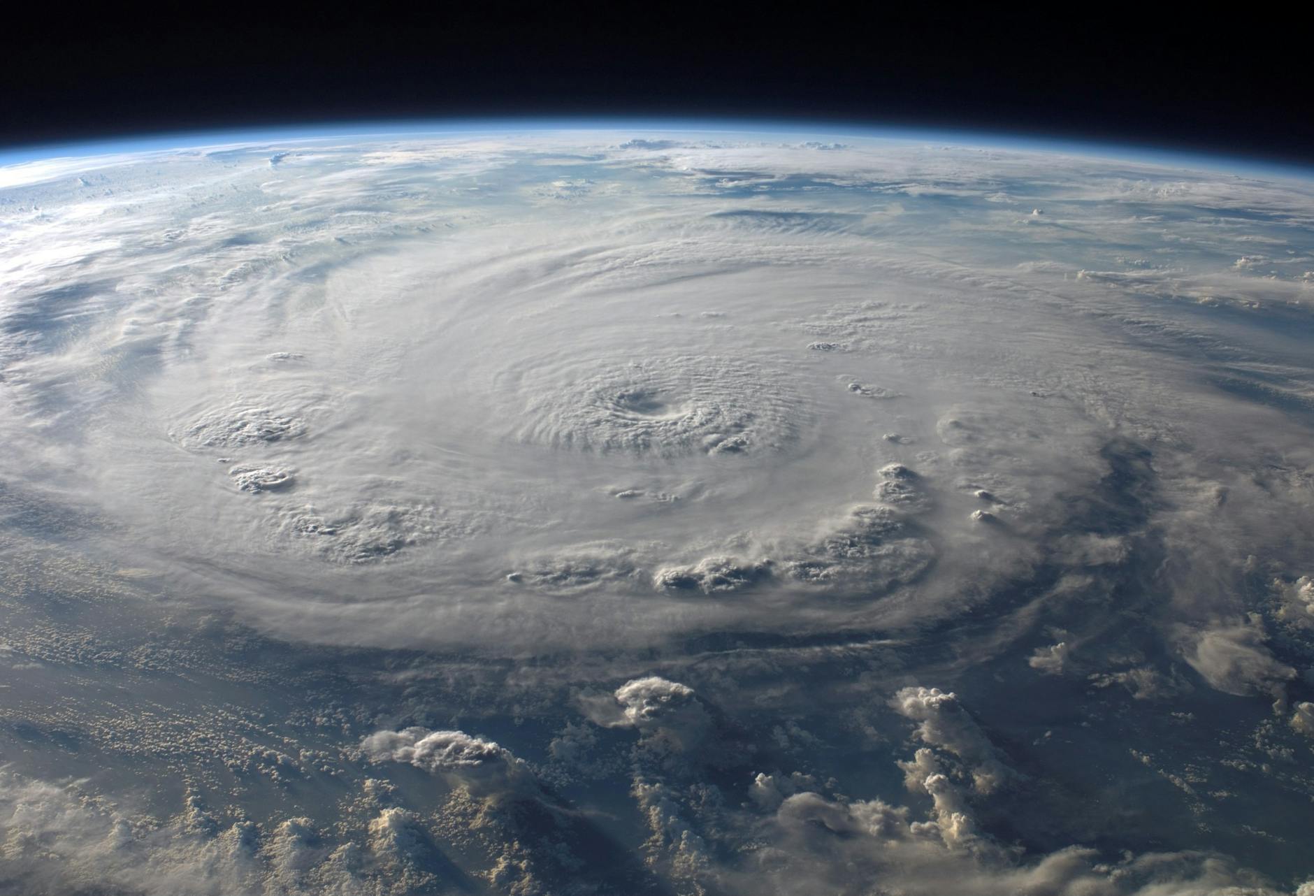
In a breathtaking display of nature’s raw power, Hurricane Erin has rapidly intensified in the Atlantic Ocean, reaching the formidable Category 5 status. The latest observations from NOAA’s GOES-19 satellite have provided an unprecedented visual chronicle of this meteorological phenomenon, capturing the storm’s development and its dramatic ascent into one of the most destructive storm categories. This event, while a natural occurrence, also serves as a critical reminder of the dynamic and increasingly unpredictable nature of our planet’s weather systems, a topic of significant interest and concern for scientists and policymakers alike.
The satellite imagery, a testament to advancements in meteorological monitoring, showcases not only the sheer scale of Hurricane Erin but also a particularly striking element: a “blaze of lightning.” This phenomenon, often associated with intense storm activity, offers valuable insights into the complex electrical processes occurring within the hurricane’s eyewall and rainbands. As Erin churned across the Atlantic, the GOES-19 satellite’s sophisticated instruments were able to document these electrical discharges, painting a vivid picture of the energy contained within the storm.
This article will delve into the development of Hurricane Erin, from its nascent stages to its peak intensity. We will explore the scientific context surrounding rapid intensification, examine the contributing factors that may have fueled Erin’s growth, and discuss the implications of such powerful storms in the current climate era. Furthermore, we will consider the broader implications for coastal communities, disaster preparedness, and the ongoing scientific quest to understand and predict these increasingly potent weather events. The data gathered by NOAA’s GOES-19 satellite not only provides a stunning visual narrative but also serves as crucial scientific data for future research and forecasting efforts.
Context & Background
Hurricanes, also known as typhoons or cyclones in different parts of the world, are tropical cyclones characterized by a large, rotating storm system with a low-pressure center, strong winds, and a spiral arrangement of thunderstorms that produce heavy rain. They form over warm ocean waters, typically near the equator, where the sea surface temperature is at least 26.5 degrees Celsius (80 degrees Fahrenheit). This warm water provides the energy, in the form of heat and moisture, that fuels these powerful storms.
The Saffir-Simpson Hurricane Wind Scale is the standard used to categorize the intensity of a hurricane. It classifies hurricanes into five categories based on their sustained wind speed. Category 1 storms have winds of 74-95 miles per hour (119-153 kilometers per hour), while Category 5 storms, the most severe, have winds of 157 miles per hour (252 kilometers per hour) or higher. Reaching Category 5 is a significant event, indicating a storm with the potential for catastrophic damage.
NOAA (the National Oceanic and Atmospheric Administration) is the primary U.S. agency responsible for forecasting the weather, including hurricanes. Through its National Hurricane Center (NHC), NOAA provides vital information, advisories, and warnings to the public and emergency managers. The GOES (Geostationary Operational Environmental Satellite) series, operated by NOAA and built by NASA, is crucial for this monitoring. These satellites provide continuous, high-resolution imagery and data of weather systems over the Western Hemisphere, enabling meteorologists to track storms in near real-time and issue timely warnings. The GOES-19, as indicated in the source, is a key instrument in this ongoing effort to observe and understand these powerful atmospheric events.
Lightning within hurricanes is not an uncommon phenomenon, but its intensity and prevalence can vary. Lightning is a natural electrical discharge that occurs during thunderstorms, caused by the separation of electrical charges within the storm clouds. The presence of significant lightning activity can be an indicator of strong updrafts and downdrafts within the storm, suggesting a highly energetic and organized system. While lightning itself is not the primary cause of damage from a hurricane, its correlation with storm intensity is a subject of ongoing scientific investigation.
The concept of “rapid intensification” is particularly concerning for forecasters and the public. This refers to a storm strengthening by at least 35 knots (40 mph, 65 km/h) in a 24-hour period. Such rapid increases in strength can catch communities and emergency responders off guard, as there is less time to prepare and evacuate. Understanding the factors that contribute to rapid intensification is a major focus of hurricane research.
The Atlantic hurricane season officially runs from June 1 to November 30, but storms can and sometimes do form outside these dates. The genesis and development of storms like Erin are closely monitored, with data from satellites, reconnaissance aircraft (hurricane hunters), and weather models contributing to the understanding of their behavior and potential track and intensity.
In-Depth Analysis
The NOAA GOES-19 satellite’s capture of Hurricane Erin’s development into a Category 5 storm offers a significant opportunity for scientific analysis. The satellite’s advanced instrumentation allows for detailed observation of various atmospheric parameters crucial to hurricane formation and intensification. The “blaze of lightning” observed within Erin provides a particularly interesting facet for study. Scientists often use lightning data as a proxy for storm intensity and convective activity. The presence of widespread and frequent lightning strikes, especially in the eyewall, can indicate strong updrafts and a highly electrified atmosphere within the storm. This electrical activity is a manifestation of the vigorous vertical motion and the release of latent heat as water vapor condenses, processes that are fundamental to a hurricane’s energy budget.
Rapid intensification (RI) is a phenomenon that poses a significant challenge to hurricane forecasting. A storm can transition from a relatively weak tropical storm to a major hurricane (Category 3 or higher) in a matter of hours. Several environmental factors are believed to contribute to RI, including:
- Warm Ocean Waters: Unusually warm sea surface temperatures (SSTs) provide ample fuel for a storm. Erin’s development likely occurred over waters with anomalously high SSTs, creating an environment conducive to rapid energy transfer. Organizations like the National Oceanic and Atmospheric Administration (NOAA) continuously monitor SSTs to assess hurricane risk. For general information on sea surface temperatures, one can refer to resources like the NOAA Sea Surface Temperature page.
- Low Vertical Wind Shear: Wind shear is the change in wind speed and direction with height. High wind shear can disrupt a hurricane’s structure, while low shear allows the storm to remain vertically aligned and strengthen. Favorable atmospheric conditions with minimal wind shear are critical for RI.
- Moist Mid-Tropospheric Air: Dry air entraining into a storm can inhibit its development. A plentiful supply of moist air in the middle levels of the atmosphere is essential for sustained convection and intensification.
- Sufficient Coriolis Force: While hurricanes can form at very low latitudes, the Coriolis effect, which causes rotation, is weakest near the equator. Storms generally strengthen more effectively at latitudes where the Coriolis force is more pronounced.
The specific combination of these factors that led to Erin’s rapid intensification is a key area for post-event analysis. Meteorologists will be examining detailed atmospheric soundings, satellite-derived measurements of heat content in the ocean, and wind shear data to pinpoint the exact mechanisms at play. Understanding these mechanisms is crucial for improving the accuracy of hurricane intensity forecasts. For information on hurricane forecasting and the science behind it, the National Hurricane Center’s About Forecasts page is a valuable resource.
The presence of lightning within the storm’s eyewall and spiral bands is not just a visual spectacle but can also provide insights into the storm’s inner workings. Research has shown a correlation between increased lightning activity and rapid intensification in some hurricanes. This suggests that the highly organized, powerful updrafts within these storms are effectively transporting charged particles, leading to more frequent electrical discharges. Scientists at institutions like NASA and NOAA are continually studying the relationship between lightning, updraft strength, and storm intensification. Data from the GOES-R Series, which includes GOES-19, is instrumental in these studies.
The term “blaze of lightning” used in the summary suggests a particularly intense period of electrical activity. This could be indicative of a very strong and well-organized storm, possibly with very powerful updrafts in its core. It’s important to note that while lightning is a symptom of powerful convection, it is not the primary driver of a hurricane’s wind speed or storm surge. However, its intensity can serve as an important diagnostic tool for forecasters trying to assess the storm’s current state and potential for further development.
Furthermore, the timing and location of lightning flashes can provide clues about the storm’s internal structure and dynamics. For example, if lightning is concentrated in the eyewall, it may indicate a robust and organized inner core. If it is more prevalent in the outer rainbands, it might suggest different inflow and outflow patterns. The advanced capabilities of GOES-19 allow for detailed mapping of these electrical phenomena over time, contributing to a more comprehensive understanding of Erin’s life cycle.
The analysis of Hurricane Erin will involve comparing its development and electrical activity to historical data from other intense hurricanes. This comparative approach helps identify common precursors and patterns associated with rapid intensification and extreme wind events. The U.S. Geological Survey (USGS) provides extensive data and research on lightning, which can be accessed through their Lightning Research and Information portal, though this focuses on terrestrial lightning, it provides general context for electrical atmospheric phenomena.
Pros and Cons
The observation of Hurricane Erin, while highlighting a powerful and potentially destructive natural event, also presents a duality of implications, offering both scientific advantages and societal challenges. Understanding these “pros and cons” is essential for a balanced perspective.
Pros:
- Advancement in Scientific Understanding: The opportunity to observe a Category 5 hurricane with such detailed satellite imagery, particularly the documented lightning activity, provides invaluable data for meteorologists and climate scientists. This data can be used to refine hurricane prediction models, improve our understanding of rapid intensification processes, and enhance forecasting accuracy for future storms. The GOES-19 satellite’s continuous monitoring is a significant asset in this regard. For more on the capabilities of the GOES-R series, the NOAA NESDIS GOES-R Series overview is informative.
- Enhanced Preparedness and Warning Systems: The detailed tracking and intensity assessment of Hurricane Erin allow for more precise and timely warnings to be issued to vulnerable coastal communities. This early and accurate information is critical for evacuation procedures, securing property, and ensuring public safety. The National Hurricane Center’s role in disseminating these warnings is paramount. Their advisories and forecasts can be found at nhc.noaa.gov.
- Validation of Satellite Technology: Events like the observation of Hurricane Erin serve as crucial real-world tests for advanced satellite technology like GOES-19. The successful capture of detailed imagery and data validates the effectiveness of these instruments in monitoring and understanding extreme weather phenomena. This technological validation is vital for future investments in space-based weather observation.
- Public Awareness and Education: Documenting and publicizing the power of hurricanes like Erin can raise public awareness about the importance of hurricane preparedness and the potential impacts of climate change. Visual evidence of these events can be a powerful educational tool, encouraging individuals and communities to take necessary precautions.
Cons:
- Potential for Catastrophic Damage: The primary “con” of a Category 5 hurricane is its immense destructive potential. High winds, torrential rain, and significant storm surge can lead to widespread devastation, loss of life, and billions of dollars in property damage. Communities in the storm’s path face severe threats to their safety and infrastructure.
- Challenges in Forecasting Intensity: Despite advancements, accurately predicting the exact intensity and rapid intensification of hurricanes remains a significant challenge. The speed at which Erin strengthened highlights the difficulties forecasters face in providing precise predictions, which can impact the timing and effectiveness of preparedness measures. The NOAA Hurricane Outlook publications often discuss these forecasting challenges.
- Economic Impact: Beyond direct damage, hurricanes have significant economic consequences, including business disruption, agricultural losses, and the long-term costs of rebuilding and recovery. The impact on global supply chains and insurance markets can also be substantial.
- Psychological Impact on Affected Communities: Experiencing a major hurricane can have profound psychological effects on individuals and communities, including trauma, displacement, and long-term stress. The recovery process involves not only physical rebuilding but also emotional healing.
- Contribution to Climate Change Discourse: While hurricanes are natural phenomena, their increasing intensity and frequency in some regions are linked to climate change. The occurrence of powerful storms like Erin often fuels discussions and debates about climate action, which can be politically charged and complex. The Intergovernmental Panel on Climate Change (IPCC) offers comprehensive reports on this topic, accessible via their official website.
Key Takeaways
- Hurricane Erin rapidly intensified to Category 5 strength, demonstrating the dynamic and sometimes unpredictable nature of tropical cyclones.
- NOAA’s GOES-19 satellite provided crucial visual data, including observations of significant lightning activity within the storm.
- The presence of intense lightning can be an indicator of strong updrafts and convective activity, suggesting a powerful and organized storm system.
- Rapid intensification is a significant forecasting challenge, influenced by factors such as warm ocean waters, low wind shear, and moist atmospheric conditions.
- The observation of such powerful storms underscores the importance of advanced satellite technology for monitoring, forecasting, and public warning systems.
- While offering valuable scientific data, Category 5 hurricanes pose severe threats to coastal communities, leading to potential for catastrophic damage and significant economic and societal impacts.
- Understanding the contributing factors to extreme weather events like Hurricane Erin is vital for improving preparedness and resilience in the face of a changing climate.
Future Outlook
The development and intensification of Hurricane Erin into a Category 5 storm serve as a stark reminder of the power and evolving nature of tropical cyclones. As climate change continues to influence global weather patterns, scientists anticipate that the conditions favorable for hurricane formation and intensification may become more prevalent. Specifically, rising sea surface temperatures are a key factor, as warmer oceans provide more energy to fuel these storms.
Research from organizations like the Intergovernmental Panel on Climate Change (IPCC) suggests a potential increase in the intensity of the strongest tropical cyclones globally. This means that storms that do form may have a higher probability of reaching major hurricane status, and the frequency of Category 4 and 5 storms could increase in some regions. The rapid intensification observed in Erin is consistent with these broader trends and highlights the ongoing challenge for forecasters to accurately predict storm behavior.
Looking ahead, the focus will remain on improving hurricane forecasting models, particularly those that predict rapid intensification. Continued investment in satellite technology, such as the GOES-R series, will be crucial. These advanced platforms provide the high-resolution data necessary to understand the complex atmospheric processes that lead to extreme storm development. The insights gained from observing storms like Erin will directly contribute to refining these models.
For coastal communities, the outlook necessitates a continued emphasis on preparedness and resilience. This includes developing robust evacuation plans, investing in resilient infrastructure that can withstand high winds and storm surge, and promoting community-level preparedness initiatives. Understanding the risks associated with increasingly powerful storms is paramount for effective adaptation strategies. Information on preparedness can be found through FEMA’s Disaster Preparedness resources.
Furthermore, the scientific community will continue to investigate the relationship between specific atmospheric conditions and hurricane intensity. Understanding the role of factors like oceanic heat content, atmospheric moisture, and wind shear will be critical. The study of lightning within hurricanes, as observed in Erin, may also offer new avenues for monitoring and predicting storm strength. Agencies like NOAA’s Climate Program Office actively fund research into these areas, contributing to our long-term understanding of climate impacts on weather.
The long-term outlook suggests a need for ongoing vigilance and adaptation. As our understanding of these complex systems improves, so too will our ability to mitigate their impacts. The data captured by GOES-19, and the analyses derived from events like Hurricane Erin, are indispensable components of this continuous effort.
Call to Action
The powerful spectacle of Hurricane Erin reaching Category 5 strength, captured with such clarity by NOAA’s GOES-19 satellite, serves as a compelling call to action for individuals, communities, and policymakers. The data gathered from this event, and others like it, underscores the critical need for proactive engagement with the realities of our changing climate and the increasing intensity of extreme weather events.
For individuals: Stay informed about hurricane forecasts and warnings issued by official sources such as the National Hurricane Center (nhc.noaa.gov). Develop and practice a personal or family emergency plan, which includes evacuation routes, communication strategies, and essential supplies. Familiarize yourself with your local emergency management agency’s guidance and recommendations. Resources for personal preparedness are widely available through agencies like FEMA (fema.gov/disaster/preparedness).
For communities: Invest in and maintain robust public warning systems and evacuation infrastructure. Conduct regular disaster preparedness drills and public awareness campaigns to ensure all residents are informed and ready to act. Support the development of resilient infrastructure, such as stronger building codes and improved drainage systems, to better withstand the impacts of extreme weather. Local and state emergency management agencies are key points of contact for community-level preparedness initiatives.
For policymakers: Continue to support and fund meteorological research and advanced satellite technologies like the GOES-R series, which are vital for accurate forecasting and early warning. Implement policies that promote climate change mitigation and adaptation. This includes investing in renewable energy, supporting sustainable land-use practices, and strengthening international cooperation on climate action. The scientific consensus on climate change, as documented by the IPCC (ipcc.ch), provides a clear mandate for such actions.
For the scientific community: Continue to leverage data from advanced satellites like GOES-19 to refine hurricane models, particularly in predicting rapid intensification. Share findings openly and collaboratively to accelerate the pace of discovery and improve forecasting capabilities. Contribute to public education efforts by translating complex scientific information into accessible formats for a wider audience.
By taking these collective actions, we can better prepare for, respond to, and mitigate the impacts of powerful storms like Hurricane Erin, ensuring greater safety and resilience for all in the face of evolving environmental challenges.
Leave a Reply
You must be logged in to post a comment.