
Hurricane Erin: A Looming Threat of Unprecedented Waves and Coastal Peril
East Coast Braces for Potential 100-Foot Waves as Hurricane Erin Intensifies
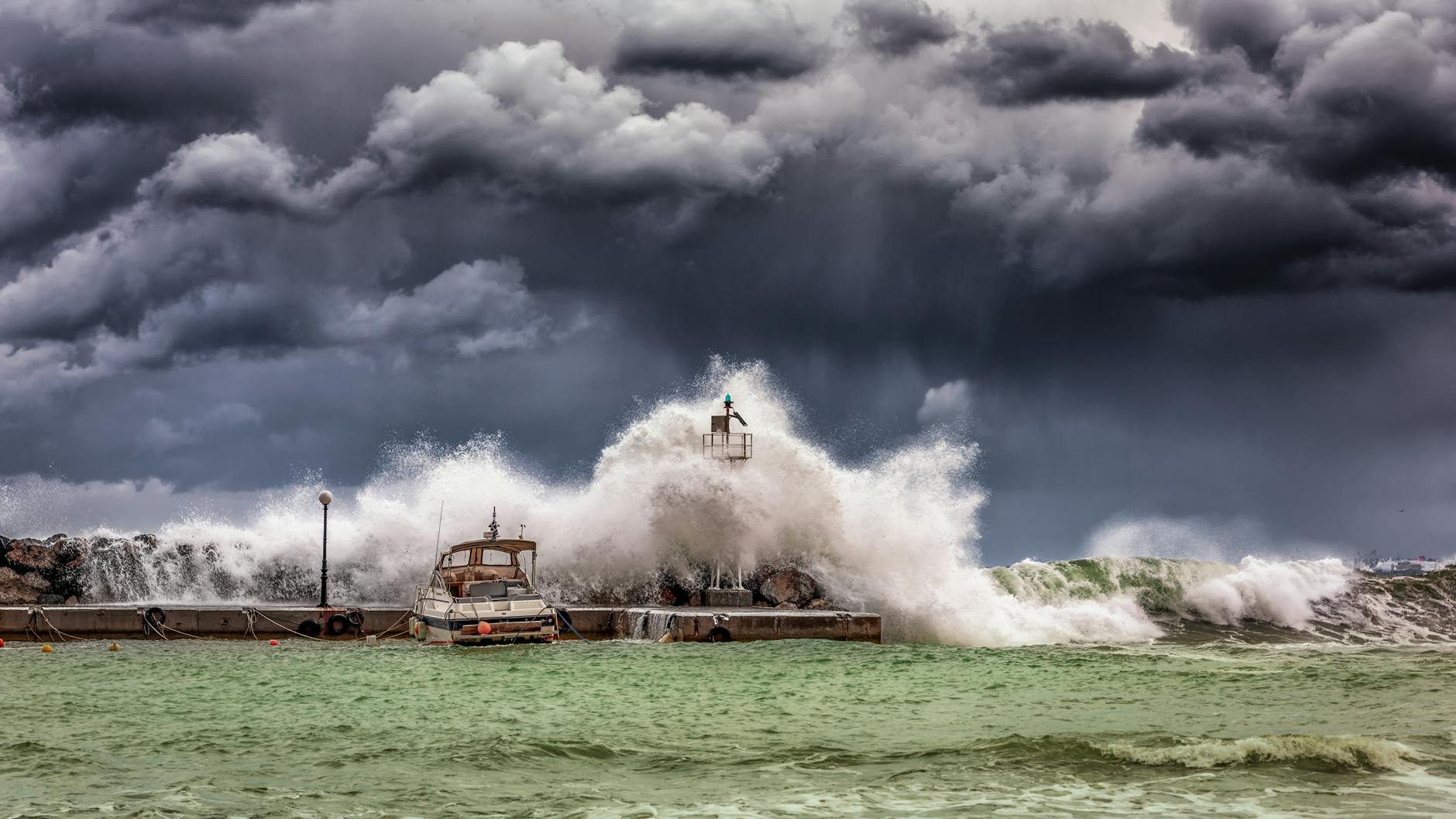
The East Coast of the United States is on high alert as Hurricane Erin, a storm of unprecedented speed and intensity, barrels toward the coastline. Forecasters are issuing stark warnings of potential 100-foot waves, a phenomenon that could bring widespread devastation and redefine coastal resilience challenges. This Category 4 hurricane is not only rapidly intensifying but also charting a course that places millions in its path, with early projections indicating severe flooding and life-threatening currents.
The sheer scale of the potential wave heights is a cause for significant concern, far exceeding what is typically experienced even by powerful Atlantic hurricanes. Such colossal waves pose a direct threat to coastal infrastructure, communities, and marine ecosystems. The rapid intensification of Hurricane Erin adds another layer of complexity, making preparedness and response efforts a race against time.
Introduction
The impending arrival of Hurricane Erin has placed coastal communities along the U.S. East Coast in a state of heightened anxiety. Forecasts from meteorological agencies paint a picture of a formidable storm, characterized by its rapid intensification and the chilling possibility of generating waves reaching heights of up to 100 feet. This article delves into the multifaceted implications of Hurricane Erin, examining its trajectory, the science behind its unprecedented wave potential, the preparedness measures being undertaken, and the long-term considerations for coastal resilience.
As a Category 4 hurricane, Erin already signifies a storm of significant destructive power. However, the projected wave heights elevate this threat to a new and potentially catastrophic level. Understanding the dynamics of such extreme weather events, the scientific basis for these forecasts, and the strategies for mitigation and adaptation is crucial for safeguarding lives and property.
Context & Background
Hurricanes are a natural, albeit often destructive, part of the climate system in the Atlantic basin. They form over warm ocean waters when atmospheric conditions are favorable, drawing energy from the heat and moisture. The intensity of a hurricane is categorized using the Saffir-Simpson Hurricane Wind Scale, which ranges from Category 1 (74-95 mph winds) to Category 5 (157 mph or higher winds). Hurricane Erin, currently classified as a Category 4 storm, possesses sustained winds of 130-156 mph, placing it among the most powerful storms.
The term “rapid intensification” refers to a significant increase in a hurricane’s maximum sustained winds over a short period. For a storm to be classified as rapidly intensifying, its wind speed must increase by at least 35 mph in 24 hours. Forecasters have noted that Hurricane Erin is exhibiting this behavior, a phenomenon that can make it particularly challenging to predict its exact track and intensity, and significantly limits the time available for evacuations and preparations.
The generation of large ocean waves is a direct consequence of strong winds blowing over the surface of the water. The fetch (the distance over which the wind blows), wind speed, and duration of the wind are the primary factors determining wave height. In the case of a powerful hurricane like Erin, sustained high winds over vast expanses of the ocean can transfer a tremendous amount of energy to the water, creating significant wave action. When these conditions are combined with factors such as storm surge – the abnormal rise of water generated by a storm, over and above the predicted astronomical tide – the impact on coastal areas can be amplified dramatically.
The East Coast of the United States is particularly vulnerable to hurricane impacts due to its extensive coastline, population density, and the geographical orientation that can funnel storms and their associated wave action inland. Historically, the region has experienced devastating hurricanes, each leaving a trail of destruction and lessons learned for future preparedness. Understanding the historical context of hurricane impacts provides a baseline against which the potential threat of Hurricane Erin can be assessed.
For detailed information on hurricane formation and the Saffir-Simpson Scale, refer to:
In-Depth Analysis
The projection of 100-foot waves from Hurricane Erin is an extraordinary meteorological event. To understand how such colossal waves can form, one must consider several contributing factors:
Wind Speed and Fetch: As a Category 4 hurricane, Erin possesses exceptionally strong and sustained winds. These winds, blowing over a large expanse of open ocean (fetch), are the primary engine for wave generation. The longer the fetch and the higher the wind speed, the larger the waves become. Hurricane Erin is expected to maintain its intensity as it approaches the coast, providing the necessary conditions for sustained powerful wave development.
Storm Surge Interaction: While waves are a distinct phenomenon from storm surge, they can interact and exacerbate coastal flooding. A high storm surge raises the baseline water level, allowing waves to reach further inland and cause more extensive damage. The combination of powerful waves riding atop a significant storm surge can create a devastating inundation of coastal areas.
Ocean Depth and Bathymetry: The underwater topography, or bathymetry, plays a crucial role in how waves behave as they approach the shore. In areas with shallower continental shelves, waves can become steeper and more powerful before they break. The specific bathymetry along different sections of the East Coast will influence the exact impact of Erin’s wave energy.
Atmospheric Pressure: The extremely low atmospheric pressure at the center of a powerful hurricane also contributes to the lifting of the ocean surface, creating a dome of water known as the storm tide. This elevated water level is a key component of storm surge.
Rapid Intensification: The rapid intensification of Hurricane Erin means that the storm is developing its destructive potential at an accelerated rate. This reduces the lead time for preparations and can catch communities off guard. The mechanisms behind rapid intensification often involve favorable upper-level atmospheric conditions, warm sea surface temperatures, and a moist environment that fuels the storm’s convective engine.
The U.S. East Coast’s diverse geography means that the impact of these waves will not be uniform. Coastal communities with lower elevations, narrower beaches, and less natural protection from dunes or barriers will be at greater risk. The cumulative effects of erosion from these massive waves could significantly alter shorelines and beaches.
For more on the science of wave formation and hurricane mechanics:
- NOAA National Ocean Service – How are waves formed?
- National Weather Service JetStream – Rapid Intensification
Pros and Cons
While the overwhelming impact of Hurricane Erin is projected to be negative, understanding potential “pros” (in a strictly meteorological or scientific sense, not in terms of human benefit) and “cons” can offer a more complete picture of the event’s dynamics.
Potential “Pros” (Meteorological/Scientific Observations):
- Data Collection Opportunity: The passage of such a powerful and unusual storm presents a significant opportunity for scientific research. Advanced monitoring equipment deployed in the storm’s path can gather invaluable data on wave dynamics, storm surge, atmospheric conditions, and the ocean’s response to extreme forcing. This data can improve forecasting models and our understanding of tropical cyclones.
- Increased Awareness and Preparedness: The stark warnings associated with Hurricane Erin can serve as a powerful catalyst for heightened public awareness and improved preparedness measures. Communities may undertake more robust planning, evacuation drills, and infrastructure hardening in response to such a significant threat.
- Potential for Coastal Renewal (Long-term and indirect): In some geological contexts, the intense energy of storm waves can contribute to the natural processes of sediment transport and redistribution, which, over very long geological timescales, can shape coastal landscapes. However, this is a highly abstract and often detrimental process in the context of human habitation and infrastructure.
Cons (Direct Impacts and Risks):
- Devastating Coastal Flooding: The most immediate and severe con is the potential for catastrophic flooding driven by both storm surge and immense wave action. This can inundate homes, businesses, and critical infrastructure, leading to widespread displacement and economic loss.
- Destruction of Property and Infrastructure: 100-foot waves possess immense kinetic energy, capable of destroying buildings, bridges, roads, and utility systems. Coastal infrastructure, including seawalls and piers, may be overwhelmed and rendered useless.
- Loss of Life and Injury: The extreme wave heights and powerful currents pose a direct and severe threat to human life. Individuals caught in the path of these waves, whether on land or at sea, face significant risks of drowning, blunt force trauma, and other injuries.
- Severe Coastal Erosion: The battering of the coastline by such powerful waves can lead to rapid and significant erosion, reshaping beaches, cliffs, and dunes. This can undermine coastal defenses and exacerbate future storm impacts.
- Environmental Damage: Coastal ecosystems, including wetlands, marshes, and coral reefs (where applicable), can be severely damaged by the powerful wave action and the inundation of saltwater. This can have long-lasting consequences for biodiversity and ecological services.
- Disruption of Transportation and Commerce: Roads, bridges, and ports may become impassable, leading to severe disruptions in transportation networks and vital supply chains. This can have significant economic repercussions far beyond the immediate coastal zone.
- Power Outages and Utility Failures: The destruction of power lines, substations, and other critical infrastructure can lead to widespread and prolonged power outages, further complicating emergency response and recovery efforts.
- Psychological and Social Impact: The trauma of experiencing such a destructive event, including potential loss of homes and livelihoods, can have profound and long-lasting psychological and social impacts on affected communities.
Key Takeaways
- Hurricane Erin is rapidly intensifying and is forecast to bring extremely large waves, potentially up to 100 feet, to the U.S. East Coast this week.
- As a Category 4 hurricane, Erin already possesses significant wind speeds and is expected to generate powerful wave action through sustained high winds, large fetch, and potentially interacting with storm surge.
- The projected wave heights are exceptional and pose a severe threat to coastal infrastructure, property, and human life.
- Coastal communities are advised to monitor official advisories and take all necessary preparedness and evacuation measures as directed by authorities.
- The rapid intensification of Erin presents a challenge for forecasting and emphasizes the need for proactive rather than reactive preparation.
- The event underscores the ongoing and increasing impacts of climate change on the frequency and intensity of extreme weather events.
Future Outlook
The trajectory and intensity of Hurricane Erin remain under constant monitoring by meteorological agencies. While forecasts provide the best available projections, the dynamic nature of hurricanes means that conditions can change rapidly. The primary concern for the U.S. East Coast is the potential for catastrophic wave action, significant storm surge, and heavy rainfall leading to widespread inland flooding.
Following the immediate impact of Hurricane Erin, the focus will shift to recovery and assessment. The scale of damage will dictate the timeline and nature of these efforts. Communities will need to contend with rebuilding infrastructure, restoring essential services, and supporting displaced populations. The long-term outlook will involve re-evaluating and potentially enhancing coastal defense strategies, zoning regulations, and building codes to better withstand future extreme weather events.
The increasing frequency and intensity of tropical cyclones, potentially linked to rising global temperatures and warmer ocean waters, suggest that events like Hurricane Erin may become more common. This trend necessitates a broader societal and governmental commitment to climate change mitigation and adaptation. Investing in resilient infrastructure, developing advanced warning systems, and fostering community preparedness are critical steps in addressing the growing threat posed by powerful hurricanes.
For updates on hurricane forecasts and preparedness guidance:
Call to Action
As Hurricane Erin approaches, preparedness is paramount. Residents in coastal areas, particularly those in projected paths of significant impact, are urged to heed all warnings and advisories issued by local and national authorities. This includes:
- Stay Informed: Continuously monitor official sources for the latest updates on the hurricane’s track, intensity, and potential impacts. Trust information from organizations like the National Hurricane Center and local emergency management agencies.
- Develop a Personal/Family Plan: Ensure you have a hurricane preparedness plan that includes evacuation routes, communication strategies, and emergency supply kits. Ready.gov provides comprehensive guidance on creating such plans.
- Secure Your Home: Take steps to secure your property, such as boarding up windows, bringing in outdoor furniture, and reinforcing doors.
- Evacuate if Advised: If an evacuation order is issued for your area, do so immediately. Do not wait, as roads can become congested and dangerous. Your safety is the top priority.
- Support Community Efforts: For those not directly in harm’s way, consider how you can support community preparedness efforts, volunteer with local response organizations, or assist neighbors who may need help.
- Long-Term Resilience: Beyond immediate preparations, consider advocating for and supporting policies that promote coastal resilience and address the underlying causes of climate change. Investing in sustainable practices and infrastructure can help protect future generations from the impacts of extreme weather.
The threat posed by Hurricane Erin is a serious one, demanding a vigilant and proactive response from individuals, communities, and governments alike. By staying informed, preparing diligently, and acting decisively, we can mitigate the risks and build a more resilient future in the face of escalating climate challenges.
Leave a Reply
You must be logged in to post a comment.